 Language
 Italian
Arabic Cartography
In this field Arabian play an important role; they raise a remarkable interest in Astronomy, Cartography,Geography, Maths but above all they maintained and continued what Greek did previously.
During a time of decline, they had the great merit to have kept alive classical studies, preventing the loss of important scientific discoveries. The importance of Arabic cartography in the development of Geography is not restricted only to this essential rescue.
Arabian were also the vehicle by which part of the classical knowledge will go back westward, setting up the rebirth of Geography during the High Middle Ages.
During the Middle Ages, while in the Western World the classical heritage is...
Medieval Cartography
The centuries going from the Roman Empire’s dissolution to the first hints of a cultural renaissance and of an economic revival around the end of the Middle Age are characterized by a mix of religious tradition, bound to the Holy Scripture, and the real knowledge about the Earth passed on by geographers, cartographers and sailors.
Classic tradition, preserved in monasteries and convents, but often deprived of its speculative, philosophic and scientific force, consequently overlies the holy source and discloses a return, almost general, to the theory of the flat Earth.
It is possible to find the tangible effect of this combination in the several world maps (mappae mundi), mostly oval,...
Roman period
Romans did not add anything to Greeks’ general and theoretical basis, like globe’s shape and dimensions, distributions of land and water, ways to represent a spherical shape on a flat surface, but their importance is based on the geo-cartographic knowledge aimed at practical requirements of the military, commercial and administrative activities.
In this field the most important evidence is given by large-scale cartography of the Empire, the Orbis Pictus, realized during Augustus reign, in which the essential elements consisted in routes, distances,administrative borders, peculiarities of the places along the paths.
This document and its tabulae, mostly used by army and government...

QVINTA EVROPE TABVLA
This is the tabula representing the “classic”areas of the Alps Northern side, of Balkans and of the Danubian region, that is a complement of the of the famous Ulma edition of Ptolemy’s Geography, named Cosmographia with the Latin translation.
This work replicates with few variations Jacobus Angelus’ translation (1409) and it is featured in the cartographic representation of Dominus Nicolaus Germanus’ (Nicholas the German) manuscript. He was a German humanist, who lived in Italy in the second half of the XV century.
The first edition came out on 16th July 1482 and it was reprinted in 1486.
In his work merged the maps of the so-called third handwritten redaction of the...

TABVLA QVINTA DEVROPA
TABVULA QVINTA DEVROPA goes with the versified remake of Ptolemy’s Geography made by the Florentine geographer Francesco Berlinghieri.
In the work there is no hint about the date, but, after the careful and meticulous studies made by the Italian scholar Roberto Almagià, we know that the document came certainly to light in 1482.
The replication is taken from a precious copy owned by Scaramangà Foundation based in Trieste.
It’s an engraving print on a metal plate, (dimensions 29,5 cm x 48,5 cm) it is framed by two black lines that compose the border graduated 1° by 1°. The illustration is split in the middle, from the top to the bottom, by a strip left in white and bounded by two...

TAVOLA VI of Europe of 1454
Representation of Italy and the nearby regions in the Greek Ptolemaic Code (Vind.Hist Gr.1) in the Österreichische Nationalbibliothek of Wien (1454).
This map composes the Tabula VI of Europe, like in all the other Ptolemaic Codes depicting Italian peninsula.
Tabula V is focused on the Eastern side of the Adriatic sea and to a big part of the Danubian area.
In this document the Adriatic Archipelago is mapped in a very schematic way and it is almost completely without toponyms indicating morphological elements as well as anthropological and settlement aspects.
The only exceptions are registered for the insular area and for Istrian peninsula marked with the Greek toponym ISRIA.

Ptolemaic code
Italy in a Ptolemaic Code written in Greek (XV century)
Adriatic Sea shores, as represented in an other Ptolemaic Code written in Greek (half XV century).
This document, stored in the Marciana National Library in Venice, has a great aesthetic value using light blue colouring for the sea, lakes and rivers and the tone ochre for the orographic development, too wide either in the southern part or in Sardinia island.

Danubian regions
Part of Danubian regions and Eastern Adriatic in Codex URBINAS GRAECUS 82 (XI century)
The map attached to the Code Urbinas Graecus 82 representing the northern side of the Alps, part of Danubian regions, with the eastern Adriatic coast and the outline of part of Italy. The original version is kept in the Vatican Apostolic Archive and dates back to XI century.
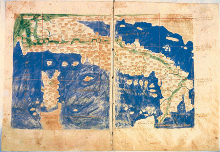
Italy and the Adriatic sea in codex URBINAS GRAECUS 82 (XI century)
Italy and the Adriatic Sea during the XI century as they are represented in the Code Urbinas Graecus 82 stored in the Vatican Apostolic Archive.
It is the most ancient cartographic code of Ptolemy’s work to have come down to us.
Here, as it is possible to notice even in the following information sheets accompanying the most ancient Ptolemaic documents, the part related to the Eastern side of the Adriatic Sea is almost always badly defined and poorly accompanied by toponymy and iconographic elements in the tabulae SESTAE regarding Italy; these characteristics are almost the same in the Latin codes, even if sometimes there are variations in the illustration and in the content.
The...
The codes
Ptolemaic documents start with Italy maps linked to Greek codes of Geographia, already circulating long before that the Latin translation was completed by Jacopo d’Angelo della Scarperia (1409).
If we must give notice for their antiquity to the traditional old boards that derives from Latin editions and that are still present in the first printed editions, of even greater significance have the so-called new boards in their different revisions.
The old boards give a completely incorrect and shapeless image of Italy and of Adriatic Sea, both from an astronomical point of view and for the figure, as well as for reliefs, hydrography, position and classification of human settlements.
Our...
1
2
